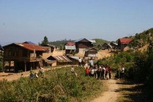
Project Phongsali 2011: We visit several locales to determine which villages we will serve this year.

This mountaintop village has had accidents with old ordnance but the location would put our small team at risk. The same is true of several riverside villages that are accessible only by boat. In selecting a locale for this year's work we need to realistically match the needs of people with our team's resources and capabilities.
Day Seven:
Our inquiries in Muang Khoua have us thinking that we’re likely to find work in one of three zones.
At the district governor’s office staff tell us that they’ve received appeals for help with ordnance from villagers living along highway 2E, which connects Muang Khoua with the Vietnam border to the east. I know that roadway well, having traveled it frequently last year. Our old US Department of Defense Bombing Survey Map for this region shows a heavy concentration of bombing along that road. Its no surprise that people continue to find bombs, rockets, mortars and other refuse of war.
We also learn that there are three villages north of Muang Khoua, accessible only by river, that also have a history of accidents with ordnance. The closest of those villages is an hour away; the most distant could be as much as three hours away, depending upon water levels and the kind of boat we use to get there.
The third zone that we’ve heard discussed is south of Muang Khoua, up a steep mountain road that is suitable for motorbikes, but doubtful for cars and trucks except during the driest part of the dry season. Apparently, up that road are villages where several accidents have recently occurred.
Yai and I decide to forego exploring the riverside villages, at least until we have visited the two zones with easier access. I’m not eager to transport of our equipment up river in boats that might prove unstable. We decide to begin our survey by visiting three villages up the mountain south of Muang Khoua.
As we drive up the mountain, I grow increasingly wary about bringing the team into this locale. The road is terrible. It takes us an hour and a half to drive 12 miles. There are no guardrails; one misjudgment could result in our truck doing swan dive off a cliff. The drive is no fun during daylight hours; only a fool would take a vehicle up or down at night. And if it rains, or even drizzles, no motorbike, car, or truck will be able to climb the steep trail until the surface completely dries.
Nevertheless, when we arrive at the first of three villages on the summit, we meet with the naiban and discuss his community’s plight; he tells us that recently two small boys were killed by old ordnance. He draws a picture in the dirt with the tip of his machete, depicting the ordnance that killed the boys; he tells us that he’s confident he has the shape and scale correct. Yai and I admire the accuracy with which he has drawn a 60-mil mortar. The naiban tell us that there are many such mortars around, and then adds, “Not so many bombies.”
The naiban’s report helps me better understand the situation here on the mountaintop. Our bomb data map indicates no airborne ordnance was dropped in this area during the war by American forces. However, the disclaimer on our map cautions that it does not include bombs dropped by either the Royal Lao Air Force or “clandestine” services (meaning the CIA’s proprietary air forces). Nor does the map include data related to ground battles.
The fact that the naiban described mortars and rockets and then minimized the presence of cluster munitions suggests that the ordnance troubling his village is likely armament left by ground troops, as opposed munitions dropped from the sky. That may well be a distinction without a difference but, nevertheless, a factor to considered when we estimate the amount of UXO we might find.
As Yai and I retraced our route and drove down the mountain, we discussed the challenges our team would face if we decided to work on the summit. From a logistical point of view, the mountain villages would be nearly as inaccessible as those along the river. None of our three cell phones (each with a different service plan) picked up a signal while we up top, so work there would cut us off from outside support; if an accident occurred we couldn’t call for help or even advice. And, emergency transport down the mountain after dark would put both victim and rescuers at risk.
I have no doubt that if I suggest to the team that we work on the mountaintop, they will readily agree. Laos is a difficult place to introduce the concept of workplace democracy. People are so happy to have a job that they accept hazards that in other countries would be unacceptable. In the end, the decision will have to be mine alone.
Yai and I are hopeful that tomorrow, when we visit the villages along the roadway, we’ll find a better locale for the kind of work our project can do.
